Forecasting Ocean ‘Weather’


Checking the daily weather forecast is something most of us do out of habit. Now, fishermen, offshore oil workers and even surfers can do the same with the Atlantic’s “ocean weather,” thanks to a model prediction tool created by professor of marine, earth and atmospheric sciences Ruoying He and his team.
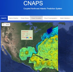
He’s Ocean Observing Modeling Group (OOMG) created a special real-time online modeling system called the Coupled Northwest Atlantic Prediction System (CNAPS), which provides users with daily and 72-hour forecasts of three-dimensional ocean circulation, wave and marine meteorology. The modeling system incorporates ocean circulation, wave and atmospheric data from weather stations, satellites and buoys in the Atlantic, and is currently operated on NC State’s High Performance Computing System.
By clicking on different tabs on the CNAPS website, users can look at marine weather including wind speed, air temperature and sea-level air pressure; wave height and direction; and ocean circulation, including ocean temperature, salinity and currents at different depths.
CNAPS covers a large ocean area: from the eastern edge of Nova Scotia to the north coast of Venezuela, including the Gulf of Maine, Middle Atlantic Bight, South Atlantic Bight, Gulf of Mexico, Caribbean Sea and western Sargasso Sea.
“The CNAPS prediction is very useful to a variety of marine operations,” He says. “Fishermen can use it to know where the currents and temperatures may be best for finding fish, Coast Guard personnel can use its current and wave forecasts during their search and rescue missions, and oil and gas workers can use CNAPS to know when dangerous ocean eddies may come to their way that may damage their equipment, just to name a few examples.
“We designed CNAPS to be a real time ‘ocean weather forecasting system,’ and we’ve been pleased with the model’s accuracy and usefulness.”
If you want to check out CNAPS, go here.
This post was originally published in NC State News.